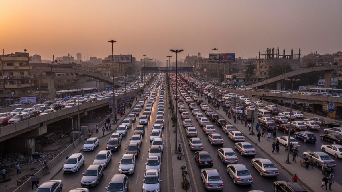
Ask anyone who has spent a rush hour crawling along Cairo's 6th of October Bridge, and they'll tell you the same thing: what should be a fifteen-minute trip can easily stretch into ninety. Cairo is regularly ranked among the world's most congested cities in global traffic indexes, and for the roughly 22 million people who live in the greater metropolitan area, that congestion is not an abstract statistic but a defining feature of daily life. Understanding why Cairo's traffic is so persistently heavy means looking past the obvious explanation of "too many cars" and into a tangle of urban planning history, population pressure, and infrastructure that has struggled to keep pace with growth.
A Daily Ritual of Gridlock
For millions of Cairenes, commuting is not a brief transition between home and work but a substantial daily undertaking that requires careful planning around known bottlenecks, prayer-time traffic surges, and school run patterns. Many residents structure their entire work schedules, including when they leave home and which route they take, around informally shared knowledge of which streets become impassable at which hours.
This lived reality has shaped Cairo's culture in subtle ways, from the popularity of home delivery services to the way business meetings are scheduled with built-in buffer time, reflecting a widespread, almost universal acceptance that travel time in Cairo is inherently unpredictable.
Just How Bad Is It, Really
Traffic analytics firms such as TomTom, which publishes an annual global traffic index, have repeatedly placed Cairo among the most congested large cities worldwide, with average commute times and extra travel time during peak hours ranking near the top of global rankings in various recent years. While exact rankings shift year to year and methodology varies between traffic index providers, the consistent theme across nearly all of them is that Cairo's congestion is not a marginal inconvenience but a structural, chronic condition of the city.
Residents themselves rarely need index data to confirm this; anecdotal accounts of two-hour commutes covering distances of a few kilometers are common enough in Cairo to barely register as remarkable among people who live there.
A City That Outgrew Its Streets
Much of Cairo's core street layout, particularly in older districts, developed long before mass car ownership was a consideration, with narrow streets designed for pedestrian and animal-drawn traffic rather than modern vehicle volumes. As the city expanded and vehicle ownership grew, urban planners faced the difficult task of retrofitting a historic urban fabric to accommodate traffic loads it was never designed for.
Newer districts built specifically with cars in mind, such as parts of New Cairo and 6th of October City, were designed with wider roads and more generous traffic infrastructure, but these areas are themselves connected to the older urban core through a limited number of arterial roads and bridges that quickly become chokepoints during peak commuting hours.
Population Growth and Rural Migration
Cairo's population has grown enormously over recent decades, driven both by natural population increase and by sustained internal migration from rural governorates toward the capital in search of economic opportunity. Egypt's Central Agency for Public Mobilization and Statistics has documented this urbanization trend as one of the defining demographic shifts of the past half-century, with greater Cairo now housing a substantial share of Egypt's total population within a relatively constrained geographic footprint.
This concentration of population growth has consistently outpaced the rate at which road infrastructure, public transit capacity, and off-street parking have been able to expand, creating a persistent structural mismatch between the number of people needing to move through the city each day and the physical capacity of the network built to carry them.
The Ring Road and Bridge Bottlenecks
Cairo's Ring Road was originally built to divert through-traffic away from the city center, and while it has succeeded in doing so to some degree, it has also become heavily congested itself as development spread along its corridor and as it became a primary route for commuters rather than purely a bypass. Several sections regularly experience severe congestion during peak hours, undermining part of its original purpose.
The Nile itself compounds the bottleneck problem, since crossing from one bank to the other requires funneling traffic across a limited number of bridges, several of which — including 6th of October Bridge and Qasr El Nil Bridge — carry traffic volumes well beyond what they were designed to handle during peak commuting windows, creating predictable daily chokepoints that have become notorious among residents.
Cairo's Informal Microbus Network
A large share of Cairo's public transportation runs through an extensive, semi-informal network of microbuses, privately operated minivans that follow flexible routes and stop on demand rather than at fixed, clearly marked stations. While this system provides crucial mobility for millions of lower- and middle-income residents who cannot afford private cars or ride-hailing services, it also contributes meaningfully to congestion, since microbuses frequently stop mid-lane to pick up or drop off passengers, disrupting traffic flow.
Efforts to formalize and regulate this network, including designated microbus terminals in some districts, have had mixed success, since the flexibility that makes microbuses useful to riders is often precisely what makes them disruptive to smooth traffic flow.
The Cairo Metro's Growing but Limited Role
The Cairo Metro, Africa's first metro system, has expanded significantly since its initial line opened in 1987, and now carries millions of passengers daily across multiple lines, with further lines under construction. Transport planners and organizations like the World Bank, which has supported financing for metro expansion, have generally identified continued metro investment as one of the most effective long-term tools for reducing Cairo's dependence on road-based transport.
Even so, the metro network's current coverage does not yet reach many of Cairo's rapidly growing outer districts, meaning a large share of daily commuters still have no practical alternative to road transport regardless of how congested it becomes, a gap that ongoing and planned line extensions are intended to gradually close.
Car Ownership Trends and Fuel Subsidy Legacy
Historic fuel subsidies, even as they have been progressively reduced since 2014, kept the cost of driving in Egypt comparatively low for years relative to income, which some transport economists argue encouraged higher rates of private car use than road capacity could comfortably absorb. As subsidies have been trimmed and fuel prices have risen, the growth rate in private vehicle registrations has moderated somewhat, though the existing vehicle stock on Cairo's roads remains substantial.
Car ownership in Egypt has also carried strong social status associations for decades, further reinforcing demand for private vehicles even in a transport environment where, from a pure time-efficiency standpoint, driving is often slower and less predictable than available public transit alternatives.
Weak Lane Discipline and Enforcement
Beyond sheer volume, Cairo traffic is also shaped by driving patterns that traffic engineers describe as low lane discipline — vehicles frequently shifting between lanes without clear markings being consistently followed, informal double-parking, and a general driving culture that tends to fill any available gap rather than maintaining consistent spacing. These patterns can reduce the effective throughput of a given road even when nominal capacity looks adequate on paper.
Egyptian traffic authorities have periodically launched stricter enforcement campaigns and infrastructure changes, including additional traffic cameras and revised fine structures under Egypt's updated traffic law, aimed at improving discipline, though enforcement consistency varies considerably by district and time of day.
Parking Scarcity and Curbside Chaos
Off-street parking is scarce across much of central Cairo, particularly in older, denser districts built long before car ownership was common, which pushes a large volume of parking onto streets themselves, further narrowing effective road width available for moving traffic. Informal valet-style curbside parking attendants, common throughout the city, add another layer of complexity to an already constrained street environment.
This scarcity has knock-on effects on congestion beyond the parked vehicles themselves, since drivers searching for available curb space, or navigating around double-parked vehicles, further disrupt the flow of moving traffic on already busy corridors.
Government Megaprojects to Ease Congestion
In response to chronic congestion, the Egyptian government has invested heavily in large-scale transport infrastructure projects over the past decade, including new flyovers, expanded ring roads, additional Nile crossings, and a substantially expanded network of highways connecting Cairo to satellite cities. Officials have periodically presented these projects as central to a broader strategy of decongesting the historic urban core by making outlying areas more accessible.
Transport researchers have generally noted that while road expansion can provide short-term relief, a well-documented phenomenon known as induced demand — where added road capacity tends to attract additional traffic over time — means that infrastructure expansion alone rarely provides a lasting long-term solution to congestion without complementary investment in public transit and urban planning.
The New Administrative Capital's Role
Egypt's New Administrative Capital, under construction east of Cairo, is intended in part to relieve pressure on Cairo's existing infrastructure by relocating government ministries, parliament, and a substantial share of the civil service workforce to a purpose-built city with wider roads and more modern transport planning from the outset. Officials have described reduced congestion in central Cairo as one of the anticipated benefits of this relocation.
Independent urban planning analysts have offered more measured assessments, noting that while relocating government functions may reduce a specific category of daily commuting traffic, Cairo's broader congestion challenges — driven by its overall population size, commercial activity, and informal transit patterns — are unlikely to be resolved solely through the new capital's development.
Economic Cost of Lost Hours
Chronic congestion carries a real economic cost, measured in lost productive hours, increased fuel consumption, and higher vehicle maintenance and depreciation costs across the economy. While precise, universally agreed cost figures for Cairo specifically are difficult to pin down given methodological differences between studies, economists studying urban congestion broadly have consistently found that severe, chronic traffic congestion imposes a measurable drag on metropolitan economic output through lost time, delayed goods movement, and reduced labor market flexibility.
Businesses operating in Cairo frequently factor congestion directly into logistics planning, delivery windows, and even hiring decisions, since employees' willingness to accept a job can depend heavily on how feasible the commute from their home district actually is.
Air Quality and Public Health Impact
Heavy, slow-moving traffic contributes meaningfully to Cairo's air quality challenges, since vehicles operating in stop-and-go congestion typically produce more emissions per kilometer traveled than vehicles moving at a steady, efficient pace. Cairo has periodically ranked among cities with elevated air pollution levels in assessments by organizations including the World Health Organization, with vehicle emissions identified as one contributing factor alongside industrial activity and regional dust.
Public health researchers have linked chronic exposure to traffic-related air pollution with respiratory and cardiovascular health risks, adding a public health dimension to what might otherwise be discussed purely as an economic or quality-of-life issue.
How Cairo Compares to Other Megacities
Cairo's congestion challenges share structural similarities with other rapidly urbanized megacities in the developing world, such as Lagos, Jakarta, and Mumbai, where population growth has similarly outpaced road and transit infrastructure expansion. Urban transport researchers studying these comparable cities have generally found that metro and bus rapid transit investment, combined with efforts to formalize informal transit networks, tend to be the most effective long-term interventions, more so than road expansion alone.
What distinguishes Cairo somewhat is the scale of its historic urban core, where narrow, centuries-old street patterns interact with a modern population far larger than anything those streets were ever designed to serve, a combination that makes purely infrastructure-based solutions more complicated to implement than in cities with more uniformly modern street grids.
Ride-Hailing Apps and Their Mixed Effect
The rise of ride-hailing platforms such as Uber and Careem in Cairo over the past decade has changed how many residents, particularly younger and more affluent ones, navigate the city, offering an alternative to both private car ownership and the informal microbus network. Transport researchers studying ride-hailing's effect on urban congestion in various global cities have generally found mixed results, since ride-hailing can reduce the need for private car ownership for some users while simultaneously adding vehicles to the road for others who previously relied on walking or public transit.
In Cairo specifically, ride-hailing has also interacted with the existing taxi and microbus ecosystem in complex ways, at times increasing overall vehicle trips on already congested corridors even as it has provided a more reliable, trackable transport option for individual riders.
What Would Actually Fix It
Transport planners and international development institutions, including the World Bank, have generally converged on a similar set of recommendations for meaningfully reducing Cairo's congestion over the long term: continued and accelerated metro and mass transit expansion, formalization and improvement of the microbus network rather than attempts to eliminate it, stricter and more consistent traffic enforcement, and land-use planning that reduces the need for long daily commutes by locating jobs and housing closer together.
None of these solutions offer a quick fix, and most require sustained investment and political commitment over many years rather than a single infrastructure project, which is part of why Cairo's traffic, despite decades of government attention and billions of dollars invested in road and transit infrastructure, remains one of the defining daily challenges of life in the Egyptian capital.
Sources
- World Bank — Supports and analyzes Cairo's public transit and urban mobility investments.
- TomTom — Publishes an annual global traffic index ranking urban congestion levels, including Cairo.
- Central Agency for Public Mobilization and Statistics (CAPMAS) — Publishes Egypt's population and urbanization data.
- World Health Organization — Assesses urban air quality and traffic-related public health impacts.
FAQ
Why is Cairo traffic considered among the worst in the world?
Cairo consistently ranks among the most congested cities in global traffic indexes such as TomTom's, driven by rapid population growth, a historic street layout not designed for modern vehicle volumes, and limited Nile crossings that create predictable daily bottlenecks.
Does the Cairo Metro help reduce traffic congestion?
The Cairo Metro carries millions of passengers daily and is widely seen by transport planners as one of the most effective tools for reducing road congestion, though its current coverage does not yet reach many of Cairo's fast-growing outer districts.
What role do microbuses play in Cairo's traffic patterns?
Microbuses form a large, semi-informal share of Cairo's public transport network and provide essential mobility for many residents, but their flexible, on-demand stopping pattern also contributes to congestion by disrupting steady traffic flow.
Will the New Administrative Capital fix Cairo's traffic problem?
The New Administrative Capital is expected to reduce some government-related commuting traffic in central Cairo, but analysts generally agree it is unlikely to resolve Cairo's broader congestion challenges on its own.
What would actually reduce Cairo's traffic congestion long term?
Transport researchers generally point to sustained mass transit expansion, formalizing the microbus network, stricter traffic enforcement, and land-use planning that shortens commute distances as the most effective long-term measures.
About the Author
We reference the World Bank, TomTom's global traffic index, Egypt's Central Agency for Public Mobilization and Statistics, and the World Health Organization to explain the background and current understanding of this topic.
Loved This Article?
Share it on WhatsApp → Share it on WhatsApp
Get more guides in your inbox — Subscribe to our newsletter for weekly surprising stories from Egypt, Saudi Arabia, Dubai, and beyond.