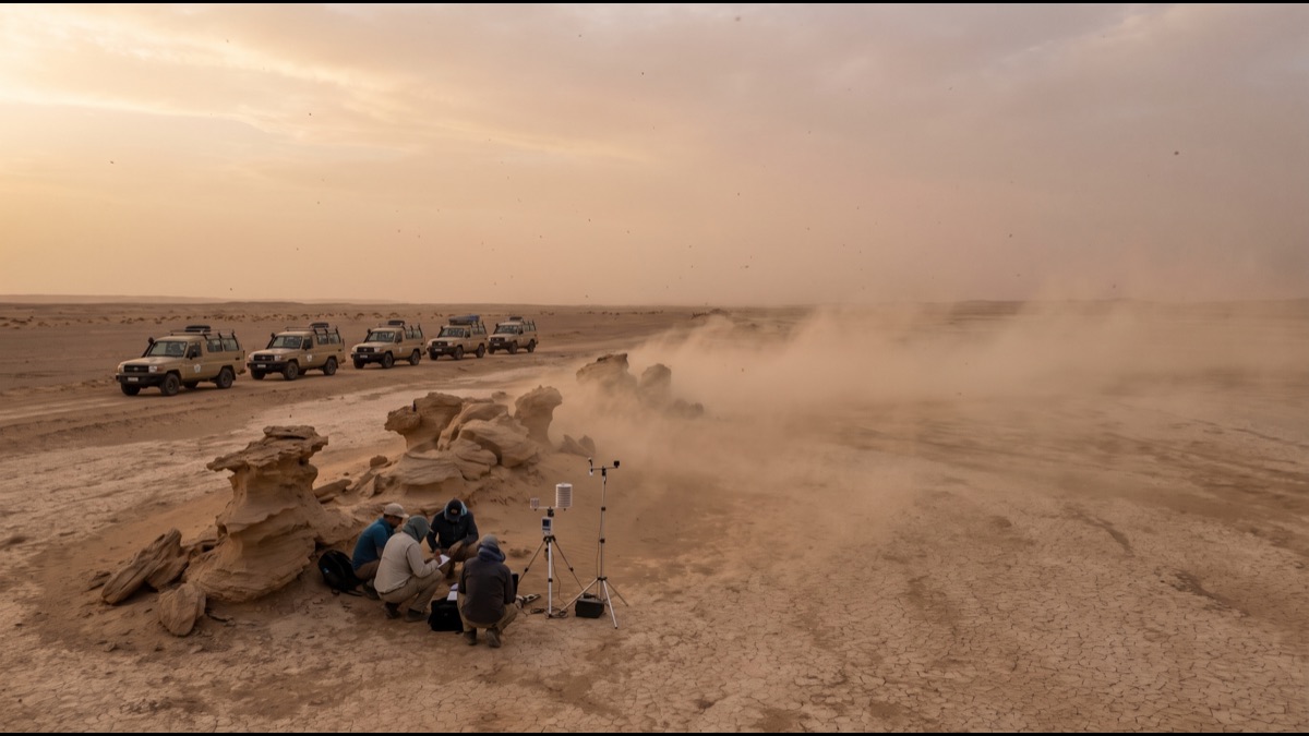
Across much of Saudi Arabia and the wider Gulf, the sky can turn from clear blue to a thick, orange-brown haze in under an hour, visibility collapsing from many kilometres to a few dozen metres as a wall of suspended sand rolls across the landscape. This is the shamal, the prevailing northwesterly wind that shapes weather across the Arabian Peninsula for a meaningful share of the year, and the mechanics behind it are considerably more specific than a simple "desert wind" explanation suggests.
The word itself comes directly from Arabic, where it simply means "north," a literal description of the wind's dominant direction as it sweeps down from the northwest across Iraq, Kuwait, and the eastern Arabian Peninsula toward the Gulf and the Arabian Sea beyond. Meteorologists use the same term the region has used for centuries because it remains the most accurate one available: this is not a single storm event but a recurring, large-scale wind pattern driven by predictable seasonal pressure systems.
What actually turns a shamal wind into a shamal sandstorm is the specific combination of wind speed, the exposed, unvegetated terrain the wind travels across, and the particular pressure setup that sustains strong flow for hours or, in the most intense summer events, for several consecutive days rather than a brief afternoon gust.
Understanding how these storms actually form means tracing the entire chain: the pressure systems that generate the wind in the first place, the seasonal differences between a winter shamal and a summer shamal, how wind speed translates into airborne sand and dust, and the very real consequences for aviation, public health, and daily life across Saudi Arabia and its neighbors once a shamal event is fully underway.
What the Word Shamal Actually Means
Shamal is the Arabic word for "north," and in a meteorological context it refers specifically to a northwesterly wind that blows consistently across Iraq, the Gulf states, and Saudi Arabia's eastern and central regions, named for the general compass direction it originates from rather than for any single storm or weather event.
Unlike a named tropical cyclone, which refers to one discrete storm system with a beginning and an end, a shamal describes a recurring wind pattern that returns predictably across specific seasons every year, driven by the same underlying pressure dynamics each time, which is precisely why meteorologists in the region distinguish between individual "shamal events" while still using the single umbrella term to describe the overall phenomenon.
The term has been used by sailors, traders, and desert travelers across the Arabian Peninsula for centuries, long before modern meteorology could explain the pressure systems actually driving it, a testament to how consistently and predictably this specific wind pattern has shaped regional weather across a very long stretch of recorded history.
The Two Distinct Shamal Seasons
Meteorologists studying the region generally divide the shamal into two functionally distinct seasonal patterns: a winter shamal, occurring roughly between November and March, and a summer shamal, occurring roughly between June and mid-September, each driven by a different combination of pressure systems and each producing noticeably different wind behavior on the ground.
The winter shamal tends to arrive in shorter, more clearly defined bursts, typically associated with the passage of a cold front moving through the region, producing strong winds for a day or two before conditions gradually settle back down, a pattern closely tied to the broader mid-latitude storm systems that periodically push south into the Arabian Peninsula during the cooler months.
The summer shamal behaves quite differently: rather than arriving as a discrete burst tied to a passing front, it is sustained by a persistent, larger-scale pressure configuration that can maintain strong, steady northwesterly wind for several consecutive days, sometimes more than a week, making it the far more disruptive and, for residents and forecasters alike, the far more consequential of the two seasonal patterns.
The Siberian High That Sets the Winter Shamal in Motion
The winter shamal is driven primarily by the seasonal buildup of a large, cold, dense high-pressure system over Siberia and Central Asia, a feature that strengthens considerably during the Northern Hemisphere's colder months as the interior of the continent radiates heat away far faster than the surrounding oceans do.
As this cold, dense air mass builds and periodically pushes southward, it interacts with lower-pressure systems moving eastward across the Mediterranean and into the Middle East, and the pressure gradient created between these systems is what actually accelerates air across Iraq and the northern Gulf as a sustained northwesterly flow, precisely the mechanism meteorologists point to when explaining a specific winter shamal event.
Because this interaction depends on the timing and strength of individual Mediterranean weather systems passing through, winter shamal events tend to be more variable in both timing and intensity from year to year than their summer counterpart, arriving as a series of distinct episodes tied to the broader mid-latitude storm track rather than as one continuous seasonal wind.
Why the Summer Shamal Is the Stronger, More Persistent Event
The summer shamal is widely regarded by regional meteorologists as the more significant of the two seasonal patterns specifically because of its persistence: rather than lasting a day or two like a typical winter event, a summer shamal can sustain strong, steady wind for five, seven, or occasionally more consecutive days, a duration that meaningfully compounds its impact on visibility, aviation, and daily life.
This persistence stems from the underlying pressure system driving it being considerably more stable and self-reinforcing during the summer months than the more transient frontal systems responsible for winter shamal events, meaning the wind does not simply gust and taper off but instead maintains a genuinely sustained flow for as long as the driving pressure configuration itself remains in place.
Summer shamal winds also tend to reach higher sustained speeds than winter events, commonly in the range of 30 to 50 kilometres per hour with gusts considerably higher during the most intense episodes, speeds genuinely sufficient to lift substantial volumes of loose sand and dust from the exposed desert surface across Iraq, Kuwait, Saudi Arabia, and the wider Gulf.
The Thermal Low That Powers the Summer Wind
The defining feature of the summer shamal is the seasonal formation of an intense thermal low-pressure system over the Arabian interior, a pressure zone that develops because the desert land surface heats up dramatically faster than the surrounding sea surfaces during the long, intense summer days, creating rising air and correspondingly lower surface pressure over the peninsula's interior.
This thermal low interacts with relatively higher pressure over the Mediterranean and the eastern Mediterranean basin to the northwest, and the resulting pressure gradient between these two zones is what actually drives sustained northwesterly wind flow across Iraq and down through the Gulf for the duration of the summer season, functioning as the summer shamal's primary engine.
Because this thermal low tends to persist and even intensify through the hottest stretch of summer, the pressure gradient driving the shamal likewise tends to remain in place for extended periods, which is the specific mechanism behind why summer shamal events last considerably longer and behave more consistently than the more episodic winter pattern.
How Wind Actually Lifts Sand Off the Ground
Sand and dust do not lift into the air simply because wind blows over them; a specific wind speed threshold, generally somewhere around 15 to 20 kilometres per hour depending on grain size, surface moisture, and soil composition, has to be exceeded before loose particles actually begin to move, a physical process researchers call saltation, in which grains bounce and skip along the surface rather than lifting cleanly into the air.
As saltating sand grains repeatedly strike the ground, they dislodge much finer dust particles that would otherwise remain bound to the surface, and it is this finer dust, rather than the heavier sand grains themselves, that actually becomes suspended high in the atmosphere and travels the greatest distances, while the coarser sand tends to stay closer to ground level, producing the visibly rolling, ground-hugging wall characteristic of the most intense events.
Exposed, unvegetated, loosely consolidated terrain, extremely common across the Arabian interior and along dried riverbeds and disturbed soil, produces dramatically more airborne dust for a given wind speed than terrain with vegetation cover or a compacted, crusted surface, which is why specific source regions within Saudi Arabia and neighboring Iraq contribute disproportionately to shamal dust loading compared to the wider desert landscape as a whole.
Inside the Wall: How a Haboob-Style Sandstorm Actually Forms
The most visually dramatic shamal events produce what is often described as a haboob-style wall of dust, a dense, advancing front of suspended sediment that can appear to residents on the ground as a genuinely towering wall rolling toward them, sometimes reaching heights of a kilometre or more before it arrives.
While the classic haboob is technically associated with the strong outflow winds generated by a collapsing thunderstorm, the Gulf region's shamal-driven dust walls form through a related but distinct mechanism: sustained, strong horizontal wind flow lifting enormous volumes of dust simultaneously across a very wide source area, rather than a single localized storm cell, producing a similarly dramatic wall effect over a considerably larger geographic footprint.
Once such a wall forms, it can advance across open desert and populated areas alike at genuinely striking speed, frequently arriving with little more than minutes of visible warning for anyone not already tracking regional weather forecasts, which is precisely why sudden, dramatic drops in visibility during shamal season catch so many residents and travelers by surprise.
Why Visibility Collapses So Fast During a Shamal Event
During the most intense shamal dust events, visibility can fall from several kilometres to under one kilometre within minutes, and in the most severe episodes to under 200 metres, a collapse driven by the sheer density of suspended particulate matter scattering and absorbing visible light far more effectively than water droplets in ordinary fog.
This rapid visibility loss is meaningfully more dangerous on roads and runways than comparably reduced visibility from fog or heavy rain, since dust storms frequently arrive with little advance warning and can intensify within a matter of minutes, leaving considerably less time for drivers, pilots, and outdoor workers to adjust behavior before conditions become genuinely hazardous.
Visibility does not necessarily improve gradually once the leading edge of a dust wall has passed; because summer shamal wind can remain sustained for days, suspended dust concentrations can persist at meaningfully reduced visibility levels for the full duration of the event rather than clearing within an hour or two the way a typical passing weather disturbance might.
The Real Impact on Aviation and Flight Operations
Airports across Saudi Arabia and the wider Gulf, including major hubs, routinely face flight delays, diversions, and in the most severe shamal episodes outright ground stops when visibility drops below the minimums required for safe takeoff and landing, a genuinely significant operational disruption given how much international air traffic now routes through the region.
Beyond visibility itself, suspended sand and fine dust pose a distinct mechanical hazard to aircraft, capable of causing measurable engine wear and, in more severe or prolonged exposure, contributing to engine performance issues, which is why airlines operating in the region maintain specific procedures for dust-related ground handling, engine inspection, and flight planning during known shamal periods.
Regional aviation authorities and airlines track shamal forecasts closely for exactly this reason, often building additional schedule buffer into summer operations specifically because a multi-day summer shamal event, unlike a brief passing storm, can meaningfully disrupt flight schedules across an entire week rather than causing a single day's isolated delay.
The Respiratory and Health Toll of Repeated Dust Exposure
The fine particulate matter suspended during a shamal event, much of it small enough to be inhaled deep into the lungs, is specifically associated with worsened symptoms for people with asthma, chronic obstructive pulmonary disease, and other existing respiratory conditions, and regional health authorities routinely issue public advisories during the most intense episodes recommending that vulnerable groups limit outdoor exposure.
Even in generally healthy individuals, prolonged exposure to elevated dust concentrations is associated with increased eye and throat irritation, coughing, and, according to a growing body of regional public health research, a measurable short-term rise in hospital visits for respiratory complaints during and immediately following the most intense multi-day summer shamal events.
Because summer shamal episodes can persist for the better part of a week, the cumulative respiratory exposure during a single severe event can meaningfully exceed what a single brief dust storm elsewhere in the world might produce, a distinction regional public health officials specifically account for when issuing air-quality guidance during the peak summer shamal months.
How Modern Forecasting Actually Tracks a Shamal Before It Arrives
Modern shamal forecasting relies heavily on numerical weather prediction models that track the specific pressure systems responsible, the strength and movement of the Arabian thermal low in summer, and the interaction between Mediterranean weather systems and the Siberian high in winter, allowing meteorologists to anticipate a shamal event several days before onset with meaningfully improved accuracy compared to a generation ago.
Regional meteorological services increasingly incorporate satellite-based dust detection, which tracks suspended particulate matter directly from orbit, alongside ground-based visibility sensors positioned at airports and along major highway corridors, giving forecasters a genuinely detailed, near-real-time picture of exactly where a dust wall is forming and how fast it is likely to advance.
This forecasting improvement has meaningfully reduced, though not eliminated, the surprise factor behind severe shamal events, allowing airports, schools, and outdoor event organizers across Saudi Arabia to issue advance public advisories, adjust flight schedules preemptively, and give residents genuinely actionable lead time before the most intense episodes actually arrive.
The Everyday Toll on Infrastructure and Daily Life
Beyond aviation and public health, repeated shamal events impose a genuine, cumulative cost on infrastructure across Saudi Arabia, from accelerated wear on vehicle engines and air filtration systems to sand accumulation on roadways that requires regular municipal clearing, particularly along desert highway corridors most directly exposed to prevailing wind.
Construction, outdoor industrial work, and agriculture across affected regions routinely adjust operating schedules around forecast shamal events, since visibility and air quality during the most intense episodes can make continuing outdoor work both genuinely hazardous and, for precision tasks, practically unworkable until conditions clear.
For residents, the practical toll shows up in smaller but genuinely persistent ways: sand infiltrating homes and vehicles through even well-sealed doors and windows, a fine dust film accumulating on outdoor surfaces within hours of a severe event beginning, and outdoor plans routinely rescheduled around forecast shamal windows during the peak summer months.
Why the Shamal Keeps Recurring Every Single Year
The shamal is not an anomaly or an unusually severe weather event in the way a single major storm might be; it is a structural, recurring feature of Arabian Peninsula climate, driven by the same seasonal pressure dynamics, the winter interaction with the Siberian high and the summer Arabian thermal low, that will continue to develop every single year regardless of any individual season's specific severity.
This predictability is precisely why regional infrastructure planning, aviation scheduling, and public health advisories are increasingly built around the shamal as an expected seasonal feature rather than treated as an unpredictable emergency, a shift in institutional response that meaningfully reduces the disruption of any single event even though the underlying wind pattern itself remains unchanged.
Understanding the actual mechanics behind the shamal, rather than treating it as simply "desert weather," ultimately explains why the region takes it seriously enough to build dedicated forecasting infrastructure, aviation contingency planning, and public health guidance specifically around a wind pattern that, however familiar and recurring, still carries genuinely significant consequences each time it fully develops.
Sources
- Wikipedia — overview of the shamal wind, its seasonal patterns, and regional impact
- National Centers for Environmental Information (NOAA) — background on regional pressure systems and dust-storm meteorology
- World Meteorological Organization — guidance on sand and dust storm forecasting and warning systems
- World Health Organization — health guidance on particulate matter exposure during dust and sandstorm events
FAQ
What does the word shamal actually mean?
Shamal is Arabic for "north," describing the prevailing northwesterly wind that blows across Iraq, the Gulf states, and Saudi Arabia, named for its dominant direction rather than for any single storm event.
What is the difference between a winter and summer shamal?
The winter shamal arrives in shorter bursts tied to passing cold fronts linked to the Siberian high, while the summer shamal is sustained by a persistent Arabian thermal low and can last five to seven days or longer.
Why is the summer shamal considered more disruptive?
It sustains strong, steady wind for several consecutive days rather than a day or two, reaching higher sustained speeds and producing far more prolonged reductions in visibility and air quality than winter events.
How much does a shamal actually reduce visibility?
In severe events visibility can fall from several kilometres to under one kilometre within minutes, and in the most intense episodes to under 200 metres, disrupting both road travel and flight operations.
Does the shamal genuinely affect flights?
Yes, airports across the region routinely face delays, diversions, and occasional ground stops during severe shamal events, and suspended sand can also contribute to measurable aircraft engine wear.
Can modern forecasting actually predict a shamal in advance?
Yes, numerical weather models tracking the driving pressure systems, combined with satellite dust detection, now allow meteorologists to anticipate most shamal events several days before onset with meaningful accuracy.
About the Author
We reference Wikipedia and other authoritative sources to explain the background and current understanding of this topic.
Loved This Article?
Share it on WhatsApp → Share it on WhatsApp
Get more guides in your inbox — Subscribe to our newsletter for weekly surprising stories from Egypt, Saudi Arabia, Dubai, and beyond.