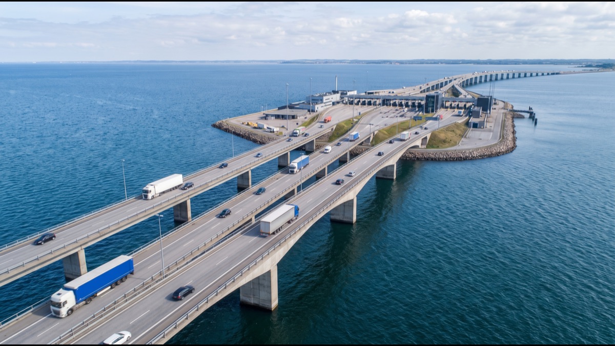
Midway across the 25 kilometres of open sea separating Saudi Arabia and Bahrain sits a fully functioning immigration and customs checkpoint, built on an artificial island that exists for no reason other than to let two countries process border crossings without either side having to extend its own coastline out into the water. Millions of vehicles cross this causeway every year, and the middle of that crossing is technically neither Saudi Arabia nor Bahrain, but a shared, purpose-built patch of reclaimed land floating between them.
The King Fahd Causeway is not a single bridge but a chain of connected bridges, embankments, and one deliberately placed island, engineered specifically to solve a set of problems that a single continuous span could not: open-water currents, shipping lane clearance, and the practical need for a physical location where two separate national governments could jointly operate a border crossing.
Understanding how it actually works means looking at why the structure alternates between solid earth embankments and elevated bridge spans rather than running as one continuous bridge, how the border and immigration process functions on a man-made island in open water, and why a project first proposed decades before construction actually began took as long as it did to complete.
It also explains why the causeway remains one of the most heavily used border crossings in the Gulf, carrying not just tourism but a genuinely significant volume of daily commuter and commercial traffic between two economies that have become deeply interlinked specifically because this fixed link exists.
Why It Is a Chain of Structures, Not One Bridge
The King Fahd Causeway consists of a series of distinct engineering sections, solid rock and sand embankments in shallower stretches of water, elevated bridge spans where ships need clearance to pass beneath, and a deliberately constructed island roughly at the midpoint, rather than a single uniform bridge structure running the entire 25-kilometre distance.
This mixed approach reflects straightforward engineering economics: building a solid embankment is considerably cheaper and simpler than building an elevated bridge span, so engineers used embankments wherever water depth and shipping requirements allowed, reserving the more expensive elevated bridge sections specifically for the stretches where ships genuinely needed to pass underneath.
The result is a crossing that alternates between driving on causeway sitting directly on reclaimed and compacted seabed material and driving on elevated spans held up by piers sunk into the seafloor, a variation largely invisible to most drivers but reflecting a deliberate cost and engineering optimization running the entire length of the crossing.
Why a Man-Made Island Sits in the Middle of the Sea
Roughly at the midpoint of the crossing sits Passport Island, an entirely artificial island built specifically to house the joint Saudi-Bahraini border control facilities, immigration counters, customs inspection areas, and supporting infrastructure needed to process the enormous daily volume of crossing vehicles.
Building this checkpoint on a dedicated artificial island, rather than at either end of the causeway on each country's own existing territory, reflects a deliberate diplomatic and practical compromise: a shared, purpose-built location avoids awkward questions about which country's border control facility travelers encounter first, and centralizes both countries' processing into a single midpoint stop rather than two separate stops at each end.
The island itself required its own dedicated land reclamation project, essentially creating solid ground where none existed before, using dredged material and engineered fill specifically designed to support the weight and operational demands of a permanent, heavily trafficked international border facility sitting in open water.
How Engineers Actually Dealt With Open-Water Conditions
Constructing bridges and causeway embankments across open sea requires accounting for water currents, wave action, and the corrosive effects of prolonged seawater exposure on structural materials, considerations that meaningfully shaped both the construction methods used and the ongoing maintenance requirements the completed structure demands.
Concrete and structural components used throughout the causeway were specifically engineered and treated to resist the accelerated corrosion seawater exposure causes to ordinary construction materials, a materials science challenge considerably more demanding than that faced by an equivalent bridge built entirely over dry land or fresh water.
The causeway's elevated bridge sections also had to be engineered with sufficient vertical clearance and structural strength to safely accommodate shipping traffic passing beneath, since the Gulf waters between Saudi Arabia and Bahrain carry meaningful commercial vessel traffic that the causeway's design could not simply block or ignore.
Why the Project Took So Long From Proposal to Completion
The idea of a fixed link connecting Saudi Arabia and Bahrain was formally proposed years before construction actually began, with the intervening period involving detailed feasibility studies, engineering design work, and, significantly, diplomatic negotiation between two sovereign governments over exactly how a shared international crossing and border facility would actually be jointly governed and operated.
This governance question, precisely how two countries would share responsibility for a single physical crossing and, specifically, the shared border facility on Passport Island, required a level of bilateral coordination considerably more complex than the underlying civil engineering challenge alone, since it touched on genuine questions of sovereignty, jurisdiction, and shared operational authority.
Construction itself, once formally underway, proceeded over several years, reflecting both the sheer physical scale of the undertaking, 25 kilometres of open-water construction, and the practical logistics of building a major piece of international infrastructure that had to satisfy engineering and regulatory requirements from two separate national governments simultaneously.
How Border Control Actually Works on the Island
Passport Island houses separate but adjacent immigration and customs facilities for both Saudi Arabia and Bahrain, allowing travelers to complete exit formalities for the country they are leaving and entry formalities for the country they are entering within a single stop, rather than processing at two geographically separate locations.
This co-located processing arrangement is specifically designed to minimize delay for the large volume of routine daily travelers, particularly commuters and short-trip visitors making the crossing regularly, for whom a lengthy or duplicated border process at two separate physical locations would impose a genuinely significant recurring time cost.
During periods of unusually high traffic volume, particularly around major regional holidays and weekends, processing time at the island facility can still increase substantially despite this streamlined design, reflecting the practical limits of any fixed-capacity checkpoint facing genuinely variable demand rather than any fundamental flaw in the underlying co-located processing concept.
Why Traffic Volume Reveals How Economically Linked the Two Countries Have Become
The causeway carries a substantial volume of daily traffic considerably beyond simple tourism, including a genuinely significant number of daily commuters, workers who live in one country and work in the other, taking advantage of the fixed land link to commute regularly between two national labor markets that would otherwise require air travel or ferry service to connect.
This commuter traffic pattern reflects a deeper economic integration between the two countries that developed substantially after the causeway's completion, since a reliable, relatively fast fixed road link fundamentally changes the practical calculus of working in one country while living in the other in a way that ferry or air connections alone could not support at comparable scale or cost.
Weekend and holiday leisure travel adds a separate, highly variable traffic layer on top of this steady daily commuter base, with the causeway experiencing dramatically higher volumes during Thursday and Friday evening periods specifically, a pattern regional transportation planners track closely when considering capacity upgrades or additional crossing infrastructure.
What Regular Maintenance an Open-Sea Structure Actually Requires
Structures exposed continuously to seawater require meaningfully more intensive and more frequent maintenance than equivalent dry-land infrastructure, including regular structural inspections specifically checking for corrosion damage, careful monitoring of the embankment sections for erosion or settling, and periodic resurfacing of the roadway itself under continuous heavy vehicle traffic.
This ongoing maintenance burden is a genuine and permanent operating cost of open-water infrastructure that a comparable inland highway simply does not face to nearly the same degree, a cost consideration factored explicitly into the original engineering and long-term operational planning for the causeway.
Specialized maintenance contracts and dedicated engineering oversight teams manage this ongoing structural monitoring and repair work specifically, reflecting the genuinely different long-term operational profile of major open-water infrastructure compared to conventional roads and bridges built entirely over dry land.
How the Causeway Compares to Other Major Fixed Sea Links Worldwide
Major fixed links connecting separate landmasses or countries across open water exist in several other parts of the world, and engineers building the King Fahd Causeway drew on established international engineering practice for open-water bridge and causeway construction rather than needing to solve every relevant technical challenge entirely from scratch.
What makes the King Fahd Causeway specifically notable within this broader category of major fixed sea links is less any single unprecedented engineering technique and more the specific combination of connecting two separate sovereign nations, requiring the shared bilateral border facility that similar domestic fixed links within a single country never need to include at all.
This international governance dimension, rather than any singularly unique civil engineering challenge, is what distinguishes the causeway most clearly from otherwise broadly comparable fixed sea-crossing infrastructure projects elsewhere in the world.
Why a Second Crossing Has Been Discussed for Years
Given the causeway's substantial daily traffic volume, periodic congestion, particularly during peak weekend and holiday periods, has prompted years of discussion and formal planning around a potential second fixed crossing, sometimes envisioned as a rail link specifically, connecting the two countries alongside the existing road causeway.
A rail-focused second crossing would specifically address a different transportation need than the existing road causeway, potentially moving a meaningful share of commuter and freight traffic onto rail infrastructure and thereby relieving road congestion on the original causeway without requiring an entirely duplicate road structure running the same 25-kilometre distance.
Progress on any such second crossing has moved considerably more slowly than the traffic congestion data alone might suggest is warranted, reflecting the same kind of complex bilateral coordination and substantial capital investment challenges that shaped the original causeway's own multi-year path from initial proposal through to actual completion.
What the Causeway Reveals About Regional Economic Integration
Beyond its direct function as a physical transportation link, the causeway is frequently cited by regional economists and policymakers as a genuinely concrete example of how physical infrastructure investment can meaningfully accelerate economic integration between neighboring countries well beyond what trade agreements or diplomatic cooperation alone typically achieve.
The dramatic increase in cross-border commuting, tourism, and commercial activity that followed the causeway's completion is regularly used as supporting evidence in broader regional discussions about the potential economic value of similar fixed transportation links being proposed or studied elsewhere within the wider Gulf region.
This demonstrated economic impact is part of why the causeway is frequently discussed not merely as a completed piece of transportation infrastructure but as an ongoing, still-relevant case study directly informing how planners and policymakers across the Gulf currently evaluate the potential of similar major cross-border infrastructure investments.
How the Structure Handles Extreme Weather Events
The Gulf occasionally experiences significant weather events, including strong winds and reduced visibility from dust storms, that can affect safe driving conditions on any exposed open-water crossing, prompting temporary speed restrictions or, in genuinely severe conditions, full closure of specific causeway sections until conditions improve sufficiently.
Structural design itself accounts for regional wind loading and wave conditions as standard engineering practice for open-water infrastructure in this specific region, meaning the causeway's physical structure is generally not itself at meaningful risk during typical regional weather events, even though driving conditions on its exposed surface can become temporarily hazardous during unusually severe weather.
Traffic management protocols for weather-related closures are coordinated jointly between Saudi and Bahraini authorities operating the crossing, another practical dimension of the bilateral cooperation the causeway's shared governance structure was specifically designed to support on an ongoing operational basis, not simply during the original construction phase.
Why This Infrastructure Represents a Genuine Diplomatic as Well as Engineering Achievement
Successfully operating a single piece of shared physical infrastructure jointly between two sovereign nations for decades, including a shared border facility requiring continuous close operational coordination, represents a genuinely significant and sustained diplomatic achievement running alongside the underlying civil engineering accomplishment itself.
This sustained bilateral operational cooperation, largely invisible to the millions of ordinary travelers who simply drive across the causeway without giving its underlying governance structure a second thought, is precisely what has allowed the crossing to function smoothly and reliably as genuinely everyday infrastructure for several decades running.
The causeway ultimately stands as a case where solving a difficult open-water engineering problem was, in a very real sense, the more straightforward half of the challenge, with the sustained diplomatic coordination required to jointly govern and operate that engineering solution across a genuine international border proving to be at least as demanding a long-term undertaking.
Why the Causeway Functions as an Economic Symbol, Not Just a Road
Since its opening, the causeway has outgrown its purely functional role to become a symbol regularly invoked in official discourse between the two countries, cited at diplomatic and economic occasions as tangible evidence of a bilateral relationship that extends beyond paper agreements into physical infrastructure ordinary citizens rely on every day.
Entire economic sectors in Saudi Arabia's Eastern Province and in Manama depend on the causeway's traffic continuing to flow smoothly, from retail and hospitality to professional services employing workers who cross the border daily, meaning any major disruption to the causeway's operation carries an immediate economic impact well beyond simple traffic inconvenience.
This dual symbolic and economic weight is part of why the causeway continues appearing in long-term regional planning discussions as a key reference example, rather than simply one piece of infrastructure among many within the broader regional transportation network.
Sources
- Wikipedia — overview of the King Fahd Causeway history, engineering, and operation
- Cooperation Council for the Arab States of the Gulf — background on regional infrastructure integration and cross-border cooperation
- Arab News — coverage of causeway traffic patterns, maintenance, and expansion discussions
- Construction Week — engineering and construction industry reporting on Gulf infrastructure projects
FAQ
Is the King Fahd Causeway one continuous bridge?
No, it is a chain of solid embankments and elevated bridge spans, using embankments in shallower water and reserving more expensive elevated bridges specifically for stretches where ships need clearance to pass beneath.
Why is there an artificial island in the middle of the causeway?
Passport Island houses the joint Saudi-Bahraini border control facilities, a purpose-built shared location that centralizes both countries’ immigration and customs processing into a single midpoint stop rather than two separate ends.
Why did the causeway take so long to build after being proposed?
Beyond the physical engineering challenge, the project required extensive bilateral diplomatic negotiation over how two sovereign countries would jointly govern and operate a shared crossing and border facility, a process considerably more complex than the construction itself.
Who actually uses the causeway on a daily basis?
Beyond tourists, a significant number of daily commuters use it to work in one country while living in the other, a pattern of economic integration that developed substantially after the causeway made reliable daily crossing practical.
Does the causeway require special maintenance because it crosses open sea?
Yes, continuous seawater exposure requires more intensive and frequent maintenance than equivalent dry-land infrastructure, including regular corrosion inspections and monitoring of embankment sections for erosion or settling.
Is a second crossing between Saudi Arabia and Bahrain being built?
A potential second crossing, sometimes discussed as a rail link, has been studied for years to relieve congestion on the original causeway, though progress has moved slowly given the same complex bilateral coordination the first crossing required.
About the Author
We reference Wikipedia and other authoritative sources to explain the background and current understanding of this topic.
Loved This Article?
Share it on WhatsApp → Share it on WhatsApp
Get more guides in your inbox — Subscribe to our newsletter for weekly surprising stories from Egypt, Saudi Arabia, Dubai, and beyond.