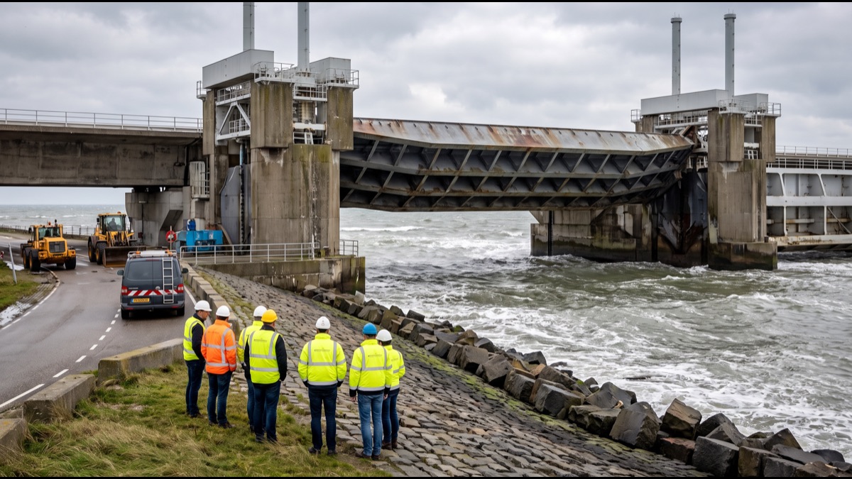
Roughly a third of the Netherlands sits at or below sea level, including some of its largest cities, and yet the country rarely floods. That is not an accident of geography but the deliberate outcome of nearly a thousand years of continuous, evolving engineering, a system of dikes, dams, pumps, and storm barriers that has turned one of Europe's most flood-prone landscapes into one of its driest and most reliably habitable.
Understanding how this actually works means understanding two separate but related problems the Dutch have had to solve simultaneously: how to keep the sea and major rivers out of land that sits below their level, and how to remove the water that inevitably still seeps, rains, and drains into that low-lying land once it is enclosed.
Why So Much of the Netherlands Sits Below the Sea
The western Netherlands occupies a low-lying delta where several major European rivers, including the Rhine and the Meuse, meet the North Sea, a landscape naturally composed of marsh, peat, and soft sediment rather than solid elevated ground.
Centuries of drainage for agriculture caused an additional problem beyond simple low elevation. Peat soil shrinks and compacts once it is drained and exposed to air, meaning that land reclaimed and drained decades or centuries ago has in many cases continued sinking slowly ever since, deepening the very problem the drainage was meant to solve.
The combination of an inherently low delta landscape and centuries of subsequent subsidence means some Dutch cities, including large parts of Rotterdam, now sit several metres below the average sea level, a gap that has widened gradually over a very long historical period rather than appearing suddenly.
This slow sinking is not evenly distributed either. Areas built on thick, soft peat continue to subside noticeably faster than areas built on sand or clay, meaning engineers cannot simply design one uniform standard of flood protection for the entire country and instead must survey and reassess ground conditions district by district as part of ongoing infrastructure planning.
How Dikes Actually Form the First Line of Defence
A dike is fundamentally a raised earthen or reinforced embankment built to hold back water that would otherwise flow onto lower land behind it, and the Netherlands has built and continuously reinforced many thousands of kilometres of these structures along its coastline, riverbanks, and lake shores.
Early dikes were built and maintained by local communities out of direct necessity, since a single breach could flood an entire village's farmland, and this communal responsibility for water management eventually evolved into some of the world's oldest continuously functioning local government institutions, the regional water boards.
Modern dikes are engineered structures designed to a specific statistical safety standard, meaning each stretch of dike is built to withstand a flood event of a certain calculated probability, with dikes protecting the most densely populated and economically critical areas built to far higher standards than those protecting sparsely populated farmland.
Dike construction itself has evolved considerably from simple compacted earth. Modern primary dikes typically combine a stable clay or sand core with an outer layer designed to resist wave erosion, an impermeable inner membrane in some designs, and continuous monitoring equipment embedded within the structure to detect seepage or subtle movement long before it could develop into an actual breach.
What a Polder Actually Is
A polder is a defined tract of low-lying land enclosed on all sides by dikes and kept artificially dry through continuous pumping, since without active intervention the land would simply flood back to its natural water level from rainfall, seepage, and surrounding groundwater.
Many of the Netherlands' most productive agricultural areas and even entire urban districts occupy reclaimed polders, land that did not exist as dry, usable ground until it was deliberately enclosed and drained, sometimes converting what had previously been open lake or shallow sea into farmland or city.
The largest single reclamation project in Dutch history converted much of the former Zuiderzee, a large inlet of the North Sea, into new land and a large freshwater lake, adding an entire province's worth of new territory to the country over the course of the twentieth century.
How Polders Are Actually Kept Dry
Continuous pumping is what actually keeps a polder dry on a day-to-day basis, moving water that collects from rain, seepage, and groundwater out of the enclosed low-lying area and into higher-level canals or directly out to sea, a process that in most polders never fully stops.
Historic windmills once provided this pumping power, and a handful of beautifully preserved examples still operate today largely for demonstration and heritage tourism purposes, but the overwhelming majority of actual pumping capacity now comes from electric and diesel-powered pumping stations operating around the clock.
Regional water boards, among the oldest democratic institutions in the country, continue to manage this pumping infrastructure, monitor water levels continuously, and levy a dedicated local tax specifically to fund the ongoing maintenance of dikes, pumps, and drainage canals within their territory.
Each polder maintains its own target water level, typically set slightly lower than the surrounding canal network so that gravity and seepage naturally draw excess water toward collection points where pumps can lift it out efficiently, a design principle that minimises the total energy required to keep an entire low-lying district dry around the clock.
The 1953 Flood That Changed Everything
On the night of 31 January 1953, a severe storm surge combined with a high spring tide overwhelmed dikes across the southwestern Netherlands, killing nearly 1,900 people and flooding a vast area of farmland and villages in what remains the country's worst natural disaster of the twentieth century.
The scale of the disaster exposed how dangerously outdated the existing dike system had become relative to the actual risk the region faced, prompting an immediate national reckoning about flood safety standards that had previously been allowed to drift well behind what the underlying geography actually demanded.
The direct political and engineering response to this catastrophe became the Delta Works, a multi-decade national infrastructure programme explicitly designed to ensure nothing resembling the 1953 disaster could ever be allowed to happen again, regardless of the enormous cost involved.
What the Delta Works Actually Built
The Delta Works comprises a network of dams, sluices, storm surge barriers, and dikes constructed across the southwestern river delta between the 1950s and the 1990s, dramatically shortening the total length of coastline requiring the highest level of flood protection by closing off several open sea inlets.
Some components are permanent dams that fully close a former sea inlet, while others are movable storm surge barriers that remain open under normal conditions, preserving tidal ecology and shipping access, and close only when a genuine storm surge threat is forecast, a compromise engineered specifically to balance safety against environmental and economic concerns.
The programme is widely regarded within civil engineering as one of the largest and most technically ambitious flood-defence undertakings ever completed, and the American Society of Civil Engineers has formally recognised it as one of the modern engineering wonders of the world.
Construction unfolded across multiple decades partly because engineers deliberately learned from each completed section before finalising the design of the next, and partly because growing environmental awareness during the project's lifespan led planners to abandon several early fully-closed dam designs in favour of movable barriers once the ecological cost of permanently sealing tidal estuaries became better understood.
How the Maeslantkering Storm Barrier Works
The Maeslantkering, completed in 1997, protects the critical shipping approach to the Port of Rotterdam, one of the busiest ports in the world, using two enormous curved steel gates, each roughly as long as the Eiffel Tower is tall, mounted on floating pontoon foundations.
Under normal conditions the gates remain open, parked in dry docks on either side of the waterway to allow unrestricted ship traffic, since closing a barrier of this scale carries real economic cost and is only justified when an actual storm surge threat is forecast.
When a computer system monitoring water levels detects a genuine storm surge risk, the barrier closes automatically without requiring human intervention, floating the two gates into position and then flooding ballast tanks to sink them onto the riverbed, sealing the waterway until the surge has passed.
How Rotterdam Manages Its Exposed Position
Rotterdam sits in an unusually exposed position, situated on a river delta below sea level while also functioning as a major working port that cannot simply be sealed off behind a permanent barrier the way some smaller coastal towns have been protected.
Beyond the Maeslantkering, the city has increasingly invested in what planners describe as water-resilient urban design, including public squares engineered to temporarily hold floodwater during extreme rainfall, and floating structures designed to rise safely with any water level increase rather than flood.
This layered approach, combining hard engineering barriers with adaptive urban design that accepts occasional controlled flooding in specific low-consequence areas, has become an influential model that delegations from other flood-exposed coastal cities regularly travel to Rotterdam specifically to study.
Rotterdam's port authority separately maintains its own extensive flood-monitoring network across the harbour area, since a working port with vast quantities of stored cargo, fuel, and industrial chemicals faces a distinct set of consequences from even a moderate flood compared to a purely residential district, requiring dedicated contingency planning layered on top of the city's broader defences.
Who Actually Manages All This Infrastructure
Regional water boards, some tracing their institutional origins back many centuries, remain responsible for local dikes, canals, and pumping stations, funded through a dedicated water tax levied on residents and businesses within their specific territory regardless of national government budget decisions.
National government agencies oversee the larger primary flood defences, including the major dams and storm surge barriers, setting the statistical safety standards each piece of infrastructure must meet and coordinating the enormous long-term investment programme required to maintain and periodically upgrade the entire system.
This layered governance structure, dividing responsibility between hyper-local water boards and national engineering agencies, has evolved gradually over centuries rather than being designed from scratch, yet is frequently cited internationally as a particularly effective model for managing flood risk at national scale.
How Climate Change Is Raising the Bar
Rising global sea levels and increasingly intense storm systems mean the statistical flood risk the Dutch system was originally engineered around is itself shifting, requiring engineers to periodically revise safety standards upward rather than treating the existing infrastructure as a permanently finished project.
Continued land subsidence in parts of the country compounds this challenge, since some areas are simultaneously experiencing rising sea levels from above and sinking ground beneath them, a combination that increases the effective flood risk considerably faster than sea-level rise alone would.
Dutch water authorities have responded by planning infrastructure upgrades and new barrier projects decades in advance, treating flood defence explicitly as a continuous, never-finished engineering discipline rather than a problem that can ever be considered permanently solved by any single generation of infrastructure.
Long-range national planning documents already sketch out infrastructure options extending well past the middle of this century, including scenarios that would require raising major dikes further, expanding pumping capacity substantially, and in a small number of the most vulnerable areas, deliberately relocating some agricultural land back into managed wetland rather than continuing to defend every hectare at any cost.
What Other Countries Have Learned From the Dutch
Dutch water management expertise has become a genuine export industry, with Dutch engineering firms and government agencies regularly consulting on flood defence projects in low-lying coastal cities around the world, including New Orleans, London, Jakarta, and numerous other exposed urban areas.
The core Dutch philosophy that has proven most influential internationally is treating flood risk as something to be actively and continuously managed at acceptable statistical odds rather than something that can be permanently eliminated, paired with genuine willingness to invest heavily in infrastructure over multi-decade timeframes.
Dutch engineers who consult abroad frequently emphasise that importing individual pieces of hardware, a particular gate design or pump specification, achieves far less than importing the underlying governance model: dedicated local funding mechanisms, statistically defined safety standards revisited on a fixed schedule, and a cultural expectation that flood infrastructure is never considered a finished, one-time project.
The Netherlands did not solve its flooding problem once and move on; it built an institutional and engineering culture that treats holding back the sea as permanent, ongoing work, continuously reassessed and upgraded as the underlying risk itself keeps changing, which is ultimately the more important lesson than any single dam or barrier.
Nearly a millennium after the earliest recorded dikes were built by local communities acting purely out of survival necessity, the Netherlands now maintains one of the most sophisticated flood-defence systems on Earth, a living demonstration that low-lying land does not have to mean unlivable land, provided a society commits to the engineering, governance, and sustained investment that keeping it dry actually requires.
Sources
- Wikipedia — overview of the Delta Works and Dutch flood defence history
- Government of the Netherlands — official information on water management policy
- Rijkswaterstaat — Dutch national agency responsible for major flood infrastructure
- American Society of Civil Engineers — recognition of the Delta Works as an engineering achievement
FAQ
Is the entire Netherlands actually below sea level?
No — roughly a third of the country sits at or below sea level, concentrated in the western provinces; the eastern and southern regions are higher ground.
What triggered the modern Dutch flood defence system?
The catastrophic North Sea flood of 1953, which killed nearly 1,900 people in the Netherlands, directly led to the multi-decade Delta Works construction programme.
Do windmills actually still pump water in the Netherlands?
A handful of historic windmills still operate for demonstration and heritage purposes, but modern polders rely on electric and diesel pumping stations instead.
What is a polder?
A polder is a low-lying tract of reclaimed land enclosed by dikes, kept dry through continuous pumping since it would otherwise flood from surrounding water.
Is climate change making Dutch flood defence harder?
Yes — rising sea levels and more intense storms are pushing engineers to continually raise design standards and plan new generations of infrastructure.
About the Author
We reference Wikipedia, the Government of the Netherlands, Rijkswaterstaat, and the American Society of Civil Engineers to explain the background and current understanding of this topic.
Loved This Article?
Share it on WhatsApp → Share it on WhatsApp
Get more guides in your inbox — Subscribe to our newsletter for weekly surprising stories from Egypt, Saudi Arabia, Dubai, and beyond.